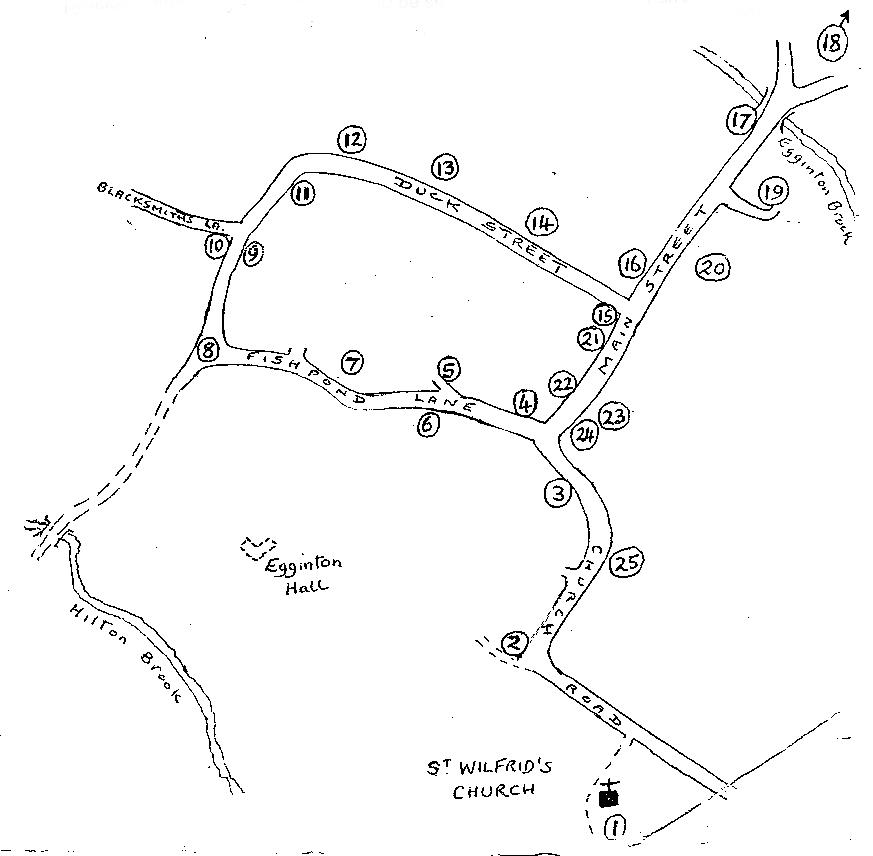
1 The Old Rectory is to be seen through the small gate to the south of the Church. It was built in c1785 replacing the earlier Rectory sited near Egginton Hall. Note the Crinkle-Crankle wall which forms the boundary between the Churchyard and the Old Rectory grounds. The shape of the wall provided shelter for the growing of fruit trees. The footpath led directly across the fields to Monks’ Bridge at a point near where the Roman Ryknield Street crossed the river. (Not now easily accessible by foot – but can be viewed by car from the A38 lay-by). This bridge was built c1257 by the monks of the Monastery at Burton who maintained it, but following the Dissolution of the Monasteries the repair work fell on local inhabitants and it is recorded that two of Egginton’s church bells were sold in 1553 to pay for repairs to the bridge. In 1775 the bridge was widened from 11 feet to 17 feet. Just beyond it a few years earlier in 1770 an aquaduct was built by James Brindley for the Trent and Mersey Canal to cross over the River Dove and in 1840 the Birmingham & Derby Junction Railway bridged the river. In 1926 Monks’ Bridge was by-passed by a new A38 road bridge.
2 Mabel’s Lodge so named after Mabel Pendleton who lived there for many years, was one of the entrance lodges to the Hall. A pair of earlier Georgian lodges were located at the entrance to the village on the A38. Through the Lodge gate can be see the re-incarnated Egginton Hall. The Tudor Hall came into the possession of the Every family when in 1623 Simon Every married Anne Leigh, the heiress and daughter of Sir Henry Leigh. After the fire of 1736 the Hall was rebuilt by Samuel Wyatt in collaboration with one of the Adam brothers. As part of the landscaping a lake and cascade were created and an iron bridge from Coalbrookdale, dated 1812, was placed in the park. This still exists, believed to be the 8th oldest iron bridge in Britain. The Hall was used as a hospital in World War I and was used by the army and the RAF in World War II. The Estate was sold in 1940. Soon after the War the Hall fell into disuse, its condition deteriorated until it was demolished in 1954. In 1994, 18 acres of the former park were acquired by Kevin and Sharon Ellis, who set about planning and building the new Hall. The new house is classical in style and pays detailed homage to its predecessor, providing a new family home in a wonderful setting alongside the original Cedar of Lebanon. Built of red brick with stone dressings, five bays by four, with a hipped roof behind a low parapet. The entrance front has a muscular Doric portico. The remaining part of the stable block and servants’ quarters have been restored.
3 The brick wall on your left is the original boundary wall of the Hall and the house now known as The Orangery is on the site of the original orangery.
4 The row of cottages now known as Cherrytree Cottages was once called Green Row as a small village green was located at this junction. Sir Henry Every, the 9th Baronet, was challenged to a duel over a hunting dispute with a certain Squire Osbaldeston. He refused Osbaldeston’s challenge, not out of cowardice, but on principle, as duelling had been made illegal some years earlier. Being apprehensive about being heckled as a coward by his tenants as he rode past, when he built this row of cottages he had the front doors placed at the back.
5 The driveway on the right leads down to a building now known as Finches Barn which was the old Estate workshop and yard which provided doors, windows and fencing for the estate properties and farms. There was also a creosote pit for preserving timber, a building for spinning flax and a tanyard. Lengths of willow were also cut for the eventual production of cricket bats. Behind the yard is a 17th century farm house now known as Cothay. The white building on the road is known as Hardwick’s Cottage. Joseph Hardwick was coachman at the Hall and for many years Parish Clerk and Vicar’s Warden.
6 The estate Home Farm was on the left. The Courtyard Archway is still in use leading to modern residences converted from the old buildings. Holmehurst beyond was listed as the Bailiff’s house in 1940 and before that was used by the Game Keeper.
7 On the right is Manor Farm House and the original buildings of the farmyard can be seen but are now converted into residences.
8 Fishpond Lane takes its name from the fish pond which was the name given to the lake in front of Egginton Hall, which can be seen from Watery Lane, the muddy lane to your left. There are osier beds there and in other places around the village. At one stage an Osier Feast was held to mark the harvest of what was an important crop used for basket making.
9 The new sign ‘Old Forge Close’ is close to the site of a Smithy. The adjacent building – Plum Tree Farm – also had a wheelwright’s shop at the nearest end.
10 Blacksmith’s Lane leads off left. The cottage on the left was once a butcher’s shop. The house across on the right (Farcroft) also had a blacksmith’s shop in its outbuildings. Further down Blacksmiths Lane, on your right, is Egginton Airfield.
11 Ivy Farm was once one of the estate dairy farms but, as elsewhere, the farmyard outbuildings have been converted into residencies.
12 Oak Tree Farm is still in use as a small-holding and a date of 1717 on one of the barns suggests this farm site predates the village relocation.
13 The next farm on the left is Rye Close Farm, although the farmhouse has been rebuilt, the old outbuildings still remain. Beyond this farm to Egginton Brook was situated one of the old ‘open fields’ of the village known as the ‘Rye Flatt’ mentioned in a deed of 1272. Across to the right is the Primitive Methodist Chapel built in 1894, now a private home. The white cottage beyond it is Woodbine Cottage, once four dwellings. It has some windows which were originally in 21 Main Street. Between it and the Chapel there was once a small caretaker’s cottage.
14 Port’s Farm on the left, probably takes its name from Sir John Port of Etwall who died in 1557 and in his will left certain of his lands including some in Egginton, to the foundation of Repton School and Etwall Hospital, now the Almshouses.
15 The Pinfold or old village pound for stray animals is located on this corner. After World War I this housed a German machine gun given to the village as a war trophy!
16 The Paddocks used to be the village shop and bakery.
17 Egginton Bridge leads out of the village over Egginton Brook probably straightened sometime after the ‘Enclosure Award’ of 1791. The present bridge was built to replace one destroyed in the floods of 1977 when the village was cut off for several days. Essential supplies had to be brought in by tractor. Across the bridge to the right was Common Farm which was converted into the present house ‘Ash Grove’. The lane was for many years known as Matron’s Lane after the indomitable Miss Catherine Jonathon, who used to live at Ash Grove, was well known as Matron at Repton Isolation Hospital and energetic chairman of Egginton Parish Council!
18 At the end of the Ash Grove Lane is Egginton Common formerly known as Egginton Heath where the largest action in Derbyshire during the Civil War took place – a skirmish in 1644 when 250 Parliamentary cavalry of Sir John Gell under the command of Captain Rhodes surprised and routed 600 Royalist cavalry, returning victorious after the battle of Newark, pursuing them into the rivers Dove and Trent. The Every’s were Royalists and probably the Hall was looted after this event.
19 The row of old cottages in William Newton Close were built in 1824 out of Parish Funds to provide 8 cottages for the poor, together with a school room, at a cost of £443. Records recall Julia Ling as school mistress. William Newton who was born in Egginton became a merchant in London and, in 1820, gave £2,000 to be invested for the poor in the village.
20 White House was originally one of the estate dairy farms.
21 Main Street (No.s 21 and 19). These buildings date from 1854. No. 21 was for many years the Post Office. It also used to have unusual windows as seen in No 19 but these were removed to a cottage in Duck Street.
22 Pear Tree Farm is now the only fully working farm left in the village.
23 Grange Court was originally Grange Farm and it is thought that the parish Tithe Barn was located here. Aerial photo shows Grange Farm about 30 years ago.
24 Elmhurst was the home of the agent for the Every estate. Beyond that was situated Gregory’s Cottage, now demolished. A sword, thought to have been hidden by a fleeing Royalist after the 1644 skirmish on Egginton Heath, was found in the thatch about 250 years later.
25 The present Memorial Hall was erected in 1857 as a Board School and enlarged in 1891. In 1902 the part of the school to the left of the entrance was built as a Parish Institute and Reading Room. After World War I, it was purchased by the village from the Every family as a War Memorial. The building is still owned by the village (via a Trust) and is rented out to Derbyshire County Council as a Primary School, doubling as the Village Hall in ‘out of school’ hours. At the rear was the old Post Office and Shop, which closed in 2007.